The Pinnacles Loop
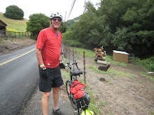
Two friends and I made a four-day bicycle tour around the Salinas Valley at the end of October. The plan was to start at the east side of The Pinnacles National Monument. We would ride south on Highway 25 to Paso Robles. Then we would cross the valley and ride north to King City, then north again to San Juan Bautista and reurn to The Pinnacles from there. John Hemiup and Steve Haas foolishly agreed to join me.
We all have some experience bicycle touring. The most difficult part of the preparation was finding a place to park the cars for the duration of the ride. The rangers at the Pinnacles would grant a special use permit to allow us to park the cars for the four days, but the permit fee is $50 and one has to apply several days in advance. I didn't mind the fee, but weather might force us to cancel the trip. I didn't want to spend $50 and then not be able to go. The solution was to drive down the night before and knock on doors at the nearby ranches to find someone who would allow us to park. The first person I found at home graciously invited us to park along the edge of her driveway. She refused my offer of payment.
I slipped into the Pinnacles campground after dark and unrolled my sleeping bag in the back of my truck. The moon was nearly full - a beautiful night for camping. I got up before dawn and flitted back out, I am ashamed to say, to avoid paying for a campsite.
Steve and John drove down before dawn. At 85 or so miles, we wanted to get this day started early to arrive at Paso Robles before dark. We saddled up in the cold. Our hands were freezing.
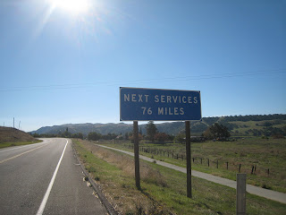
The road led into increasingly remote terrain once we crossed Highway 198. One concern was where we would find water along the way. There are no commercial services for at least 75 miles. We stopped at some ranch buildings to ask for water. Not finding any sign of human

presence, we helped ourselves from a hose (coiled in unfortunate proximity to a pile of horse manure).
 We lunched along the road. Over a couple of hours, we were undisturbed by traffic other than a few motorcyclists.Peach Tree Road peters out just as it reaches the end of Indian Valley Road. We climbed a fifteen percent grade to reach the crest of Indian Valley. That took all I had. We gratefully began a long descent that led to vineyards and the Big Sandy Creek. The
 road stayed to one side of the creek, probably to avoid flooding. Unfortunately, that made the
road roll up and down the ends of the ridges at the side of the valley. With 75 miles behind us,
we were already tired. As we reached each crest, we saw another downslope and another upslope ahead. Highway 25 winds through rolling oak-studded hills. The only habitations are occasional ranches. Tarantulas in the mood for love cross the road now and then looking for a date.
Nevertheless, as long as you keep turning the crank, every ride eventually comes to the end. We crawled into Paso Robles. After showers, we were refreshed. We found some good and abundant Mexican food. I spread my sleeping bag on the floor of Steve and John's motel room. Ahhh!
Paso Robles has a big car show every year. I noticed a surprising number of custom cars cruising around the streets. The town has retained an attractive old-fashioned look. Antique facades and shade trees. I bet there's some nice B&B's here.
Saturday's ride would take us on Nacimiento Road to Lockwood and then to King City. We got up a little late. With only 70 or so miles to go, we weren't concerned about darkness, but the
terrain is remote so we wanted to be sure that there would be food somewhere along the way. I pressed the motel manager for information. He's lived in Paso Robles for 50 years, he said.
Never been out there! We leisurely ate a big breakfast at the cafe. Nobody at the cafe knew

anything about the road beyond Lake Nacimiento. I'm surprised at how incurious many people are. I vaguely remembered a country store from a previous ride. No way to be sure the store was still in operation but we figured we'll take the chance.
More rolling terrain. Short climbs, but
moderately steep. After crossing the dam at Lake
Nacimiento, we had a longer, hot climb, 600 feet in the sun. We helped ourselves to water from a hose at the top for fear that would be the last water we would see for many a mile. Not to worry. We immediately had a screaming descent to the Bee Rock Store. This delightful oasis offered cold beverages, hot pizza, and
motorcyclists to yak with.  A leisurely lunch
A leisurely lunch ensued. It's surprising how the day can get away from you. Some sense that we ought to have an
eye on the daylight crept up on us. We shook
those negative thoughts off! An hour later, we
stopped at the Lockwood store for a Coke. We
talked with a sergeant from Hunter-Liggett about making a six-mile side trip to Mission San Antonio de Padua on the military base. He
advised that we could take a shortcut back to the Jolon Road to King City from the mission. He
warned that there would be some butt-kicker hills on the shortcut. At the entrance to Hunter-Liggett, we asked the guards about the
shortcut, Sulfur Springs Road. "All flat or downhill" they reported. "That'll go fast", we figured.
"Let's go." We figured we would be in King City by dusk.

The mission is charming, well worth a visit. The
post public safety office was conveniently
located at the foot of Sulfur Springs Road. I checked with the duty officer - "No climb, pretty flat" was the description. Twenty minutes later, we were grinding up a grade in granny gear, watching the shadows grow longer! The moon rose. By the time we reached Jolon Road toward King City, full dusk. Eighteen miles still to go!!
We endured another long climb. By then it was full dark with a steep descent into King City. We all had headlights and taillights, but our battery-powered headlights, while perfectly adequate for alerting oncoming drivers, produce pathetic illumination for actually seeing the road surface more than a few feet ahead. Is there some debris in the dark on the roadway or a pothole that will throw me off my bicycle? Should I crawl along at a safe speed for my headlight range, maybe five miles an hour, or let go of the brakes and trust in the god of fools to get the ride over with and have a shower and dinner? What would you choose? We went for it. We were lucky.The Jolon Road ends at Highway 101 outside King City. The choices were, get on the freeway
going north or get on the freeway going south. A sign for a bicycle path had caught our eye a little way back. Seeing no alternative, we pedaled back the bicycle path. We had no idea where it went. We figured it had to better than where we were, so rode off into the dark. After about a mile, we emerged into a pool of light surrounding a motel and a Denny's. Were we grateful? Did we vow never to let darkness fall on us on the road again? You bet!
We got up a little late and went over to Denny's for breakfast. An interesting facet of a bicycle tour is the justification it grants for eating whatever you want. This is most manifest at breakfast. People who otherwise choose their food with respect for both their health and the planet will order a plate of cholesterol that would cause a Tasmanian devil to swallow a bottle of Lipitor and then they'll ask "Can I get biscuits and gravy with that?"
The guard at Hunter-Liggett told us yesterday that King City should be marked on the map with a skull and crossbones. Wyatt Earp would be afraid to walk the streets. Maybe it's a tough
town after dark. In the Sunday morning sun, it seemed neat and attractive enough in a working
class style.

We rolled north on Metz Road, parallel with the Salinas River. For an hour, we made good time on a flat road with no traffic. Hills then began to slow us down. We turned down to Soledad to cross Highway 101 and the river and ride the flatter Fort Romie and River Roads on the west
side of the river. There's no bridge to go directly across, however. We had to ride south along
the shoulder of the freeway (that's permitted where there's no alternate route for cyclists and
pedestrians) for one exit. Riding on the freeway is probably safer than on a conventional road
because there's always a wide shoulder and because cyclists draw the motorists' attention more on the freeway. The roar of the traffic still makes riding on the freeway an intimidating
experience.

stan ds in a niche behind the altar.


ds in a niche behind the altar.Onward to Gonzales through farm fields. Peppers, cactus, vineyards. We crossed the Salinas River again. We settled into a Mexican restaurant. Perhaps the staff was waiting for some customers to show up before starting the kitchen. At least 35 minutes passed before there
was any sign of food. Someone recalled that the change to Standard Time meant that sunset would come an hour earlier. Oops! To compound our problem, a headwind rose. Back on our bikes, we formed a pace line to minimize wind drag and maximize speed. We made good time
for an hour along Old Stage Road. Following close on the wheel of the rider in front without collisions requires more concentration than I can easily muster; I was glad to abandon that effort.
San Juan Grade is a one-lane road that winds up through the hills from Salinas to San Juan Bautista. It's about a 750 foot climb. There was no hope that we would reach San Juan Bautista before dark, but maybe we wouldn't be far from town. I was convinced that we had to make a turn on Crazy Horse Road to find the Grade. We were about two miles off-course before I realized my error.
The four-mile digression delayed our start on the Grade; we wouldn't even reach the summit before dark.
The boundary between Monterey County and San Benito County is at the top. San Benito County evidently has no money to maintain the road surface on this byway - the pavement was terrible from that point on. Our descent in the dark was in fear of hitting a pothole or crack and losing control. Fortune favors fools; we got down safely.
Steve and John parked at the motel while I found the RV park.
The RV park is the kind of place that employs old toilet fixtures as planter boxes but their lawn was a perfect place for me to unroll my sleeping bag. We found a Basque restaurant for dinner.
The last leg of the journey began with a visit to the mission. We found backroads to parallel Highway 156 to Hollister. We passed a bodega which was starting to barbeque tri-tip for the day. We stopped at the Country Rose Cafe, filled with customers of a size to indicate that they are serious about their eating. The Mexican Scramble breakfast was heaped on a plate a little smaller than my bicycle wheel; it's a meal to make life worth living! We discussed whether to return to the Pinnacles the hard way on Cienega Road or the easy way on Highway 25. The easy way won. We'll save Cienega Road for another time.
The total ride was about 270 miles in about 24 riding hours. Beautiful weather throughout, sunny and cool to warm. No flats. No injuries. Still speaking to each other. I count the ride as a success! 
posted by Jerry Harrison @ 9:49 AM
0 comments
![]()